
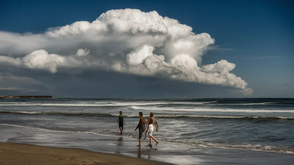
The phrase “tsunami roll cloud Portugal“ has rapidly gained attention after breathtaking videos and photos captured a massive rolling cloud advancing across Portugal’s coastline. At first glance, the cloud appears remarkably similar to an approaching tsunami, creating moments of panic among beachgoers before revealing itself as a spectacular atmospheric event rather than a dangerous ocean wave.
This extraordinary weather phenomenon fascinated meteorologists, photographers, and travelers alike. Although its appearance can be intimidating, the tsunami roll cloud is a rare cloud formation produced by unique atmospheric conditions. In this comprehensive guide, we explore everything about Portugal’s tsunami roll cloud, including how it forms, why it happens, whether it is dangerous, where it can be seen, and why Portugal’s coastline creates ideal conditions for this mesmerizing display.
What Is a Tsunami Roll Cloud?
A tsunami roll cloud is not actually related to a tsunami. Instead, it is a spectacular roll cloud, a type of arcus cloud that forms horizontally and appears to roll across the sky like an enormous atmospheric wave.
The nickname “tsunami cloud” comes purely from its visual resemblance to a giant ocean wave approaching land. Unlike an actual tsunami, this cloud remains suspended in the atmosphere and poses no direct flooding threat.
Roll clouds are detached from thunderstorms and rotate slowly around a horizontal axis. Their impressive appearance often creates dramatic scenes, especially when viewed over the ocean.
Why Did the Tsunami Roll Cloud Appear in Portugal?
Portugal’s western coastline experiences unique weather patterns because of its location beside the Atlantic Ocean. During periods of intense summer heat, the land warms much faster than the ocean.
As cooler marine air pushes inland beneath warmer air, a strong boundary develops. When atmospheric moisture, wind direction, and temperature differences align perfectly, a massive roll cloud can form.
Several ingredients contribute to this phenomenon:
- Warm land temperatures
- Cool Atlantic sea breeze
- High humidity
- Stable atmospheric layers
- Temperature inversion
- Wind convergence
When these conditions occur simultaneously, they produce the spectacular rolling cloud seen along Portugal’s beaches.
Why Does the Cloud Look Like a Giant Tsunami?
The optical illusion is what makes this weather event so famous.
From a distance, the cloud appears to:
- Rise vertically from the ocean
- Curl over like a breaking wave
- Move rapidly toward land
- Cover the horizon from end to end
Combined with changing sunlight and dark cloud shadows, the effect becomes astonishingly realistic.
Many first-time observers mistakenly believe a real tsunami is approaching until they realize the “wave” remains in the sky rather than the sea.
Is the Portugal Tsunami Roll Cloud Dangerous?
For most people, the answer is no.
A roll cloud itself is generally harmless. However, it often indicates rapidly changing weather conditions that may include:
- Strong gusty winds
- Sudden temperature drops
- Brief heavy rain
- Thunderstorms nearby
- Rougher sea conditions
Beachgoers and sailors should remain aware of changing weather whenever such clouds appear.
Although the cloud is visually dramatic, it is not capable of producing tsunami waves or coastal flooding.
Meteorological Science Behind Roll Clouds
Meteorologists classify roll clouds within the arcus cloud family, which includes shelf clouds.
Unlike shelf clouds that remain attached to thunderstorms, roll clouds become detached and continue moving independently.
The rotating appearance develops because:
- Cool dense air slides beneath warm humid air.
- Warm air rises.
- Moisture condenses.
- Wind shear creates horizontal rotation.
- Continuous condensation maintains the cloud’s cylindrical shape.
This creates the illusion of an enormous rolling barrel moving across the sky.
Why Portugal Is an Ideal Location
Portugal possesses several geographic advantages that encourage these formations.
Atlantic Influence
The Atlantic Ocean supplies cool marine air throughout the summer.
Hot Inland Temperatures
Portuguese summers frequently exceed 35°C (95°F), creating strong temperature contrasts.
Long Coastline
Hundreds of kilometers of coastline allow sea breezes to travel inland efficiently.
Humidity
Moist Atlantic air provides enough water vapor for cloud formation.
These ingredients make Portugal one of Europe’s most photogenic locations for unusual cloud events.
Where Was the Tsunami Roll Cloud Seen?
The remarkable cloud was observed across several coastal areas, including popular beaches where thousands of tourists witnessed the spectacle.
Many photographs showed the cloud approaching famous seaside destinations before passing overhead.
Observers described:
- Rapid movement
- Cool winds
- Sudden shade
- Spectacular photography opportunities
- Calm ocean beneath an intimidating sky
Social media quickly spread videos worldwide, leading millions to search for “tsunami roll cloud Portugal.”
How Rare Is This Weather Event?
Roll clouds are considered relatively uncommon.
Although they occur in various parts of the world, the perfect atmospheric conditions required make them infrequent.
Some of the best-known locations include:
- Portugal
- Australia
- United States
- Argentina
- Brazil
Australia’s Morning Glory Cloud is perhaps the world’s most famous roll cloud, stretching hundreds of kilometers.
Portugal’s event gained attention because of its remarkable resemblance to an incoming tsunami.
Difference Between a Roll Cloud and a Shelf Cloud
Many people confuse these two cloud types.
| Roll Cloud | Shelf Cloud |
|---|---|
| Detached from storm | Connected to storm |
| Rotates horizontally | Usually stationary appearance |
| Barrel-shaped | Wedge-shaped |
| Can exist independently | Forms along storm fronts |
| Rare | More common |
Understanding these differences helps explain why Portugal’s cloud appeared so unique.
Public Reaction to the Portugal Tsunami Cloud
Videos quickly accumulated millions of views online.
People described the cloud as:
- Unreal
- Apocalyptic
- Like a movie scene
- A giant wave in the sky
- One of nature’s greatest illusions
Some beach visitors briefly feared a real tsunami before learning the scientific explanation.
Meteorologists reassured the public that the cloud represented an atmospheric phenomenon rather than a geological hazard.
Can Climate Change Cause More Roll Clouds?
Scientists have not established a direct connection between climate change and increased roll cloud frequency.
However, changing weather patterns may influence:
- Temperature extremes
- Humidity levels
- Atmospheric instability
- Sea breeze intensity
Additional research is needed before drawing firm conclusions.
Photography Tips for Capturing a Tsunami Roll Cloud
Photographers seeking dramatic weather images should:
- Use wide-angle lenses
- Capture the full horizon
- Photograph from elevated viewpoints
- Include foreground subjects for scale
- Shoot during sunset for dramatic lighting
- Use fast shutter speeds if winds increase
Because roll clouds move quickly, preparation is essential.
Safety Tips During a Roll Cloud Event
Although generally safe, visitors should take sensible precautions.
- Monitor local weather forecasts.
- Leave the beach if strong winds develop.
- Secure loose belongings.
- Avoid swimming during rapidly changing weather.
- Seek shelter if thunderstorms follow.
Remaining weather-aware ensures both safety and enjoyment.
Why the Portugal Tsunami Roll Cloud Became a Global Sensation
Several factors contributed to its viral popularity.
First, its appearance closely resembled an enormous tsunami.
Second, modern smartphones allowed thousands of people to capture high-quality footage simultaneously.
Third, social media platforms rapidly spread videos worldwide, introducing millions of viewers to a weather phenomenon they had never seen before.
Finally, Portugal’s beautiful coastline provided a dramatic backdrop that enhanced the visual impact of the rolling cloud.
Conclusion
The tsunami roll cloud Portugal event stands as one of the most remarkable weather phenomena witnessed along Europe’s Atlantic coastline. Despite its intimidating appearance, the cloud is not a tsunami but a rare atmospheric formation created by the interaction of warm land, cool ocean air, humidity, and favorable wind conditions. Its wave-like structure offers a striking reminder of nature’s ability to create breathtaking optical illusions. For meteorologists, photographers, and travelers alike, Portugal’s tsunami roll cloud remains an unforgettable example of the beauty and complexity of Earth’s atmosphere.
Frequently Asked Questions (FAQs)
What is the tsunami roll cloud in Portugal?
It is a rare roll cloud, a cylindrical atmospheric formation that resembles a giant tsunami but is completely unrelated to ocean waves.
Is the tsunami roll cloud dangerous?
The cloud itself is generally harmless, although it may signal strong winds, sudden weather changes, or nearby thunderstorms.
What causes a roll cloud?
Roll clouds develop when cool, dense air pushes beneath warm, humid air, creating horizontal rotation and condensation.
Can a roll cloud produce a tsunami?
No. Roll clouds are atmospheric phenomena and have no connection to seismic activity or tsunami generation.
Why did the Portugal roll cloud become famous?
Its extraordinary resemblance to a giant ocean wave, combined with viral videos shared across social media, made it an international sensation.
